user manual
Scenery options:
Micro Flight supports three types of scenery:
- Tile based scenerey, with automatic texture generation.
- Photorealistic scenery, with single object and texture definition file.
- USGS imported scenery with tile based object files.
The tile based scenery is the most common scenery type in Micro Flight, it is defined by a large bitmap which holds the DEM ( Digital Elevation Model ) , and another which holds the objects information.
The texture for this type of scenery is generated by interpolating between textures which are associated with elevation and producing a smooth blending between them.
The benefit of this type of scenery is that it can use very few textures to produce a seamless photorealistic view which is related to the elevation data, an example can be seen in this image:

The photorealistic scenery is based upon a large aerial photo, the textures are extracted directly from this photograph, the elevations are taken from an ascii text file and the objects can be built using a single data file.
The benfit of this type of scenery is that it can reproduce a small well defined area with a good accuracy, the disadvantage is that the texture is big and take a lot of memory and disk space.
This type of scenery typically takes just a small portion of the map as the texture file cannot be as large as the elevation map, such a scenery can been seen in the following image:

The USGS imported scenery is designed to make use of the extensive data available on the web at the USGS download site.
The import process requires using the popular 3DEM software made by Visualization Software LLC by Richard Horne, the software can be downloaded here.
The process of importing this type of scenery to Micro Flight is simple:
- Download the DEM file from the USGS server.
- Load the file into 3DEM using "Load terrain model".
- From 3DEM select "Save terrain matrix" as a binary signed integer file.
- Take the files created (*.bin and *.hdr) and put them into an empty directory.
- Take a few terrain textures and place inside the new scenery directory.
- Run Micro Flight and select the new scenery.
The benfit of using Micro Flight with this type of ecenery is enourmous, you can navigate real USGS scenery and fly inside it, making Micro Flight an essential tool for anyone working with this type of data.
An example of this type of scenery can been seen in the following image:

Graphic options:
To adjust the graphic options of the program select the graphics options from the menu, this will show the following screen:
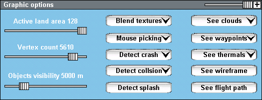
The three sliders on the left control the complexity of the scene and can have big influence on frame rates.
The "Active land area" controlls the size of the terrain grid, the larger it is the larger the grid will be, the number of polygons/vertices rendered is relative to the square of this number.
If your frame rates drop below 20 fps it is recommended to change the active land area to 80 or less, instead of the default 128.
The "Vertex count" slider controlls the amount of optimization made on the grid and the vertex count after optimization.
The "Objects visibility" slider controlls the visibility of land objects, this has great effect when the scene is dense with objects.
The "Blend textures" option enables the blending of land textures, this blending makes the land look seamless, but at the same time requires processing time and graphic memory, if you experience low frame rates you may try to disable this option.
This option has no effect on photoreslistic scenery where the textures are taken directly from the photo and not blended in runtime.
Mouse picking:
The "Mouse picking" option enables you to manipulate instruments, handles and control surfaces by pressing them with the left mouse button and moving the controlled item.
As you press on the item, the mouse cursor will show the direction of possible manipulation.
When the joystick is turned off, the mouse picking can be used to control the plane directly by moving the stick, throttle, rudder and handles inside the cockpit.
When picking and joystick are turned off, the mouse movement is used as stick input.
An example of mouse picking can be seen in the following image:
 |
|
| 1. flaps - press and move up/down | 4. stick - press and move in all directions |
| 2. rudder - press and move left/right | 5. trim - press and move up/down |
| 3. gear - press and move up/down | 6. cable - press and move up/down |
Simulating a pre-flight check:
Mouse picking can be used for moving control surfaces outside the plane, you can simulate a pre-flight check in the following way:
- Press F2 to be in chase view.
- Open the joystick menu and make sure the joystick axes are disabled.
- Move the control surfaces of the plane as you would have when making a pre-flight check.
Crash detection:
Crash testing and object collision can be enabled by selecting the following options:
Detect crash - check if plane has been broken by overstress, or ground impact.
Detect collsion - check if plane has collided with another plane or object.
Detect splash - check if plane is at sea level and assume water impact.
Visibility:
These options enable the visibility of the following items:
See clouds - transparent clouds cuase massive frame rate loss, this option disables them.
See waypoints - waypoints appear as yellow markers in the scene, they can be made invisble with this option.
See wireframe - shows the entire scene in wireframe, this option is usefull when changing land resolution and vertex count, and also when being towed by a plane that is hidded by your instrument panel.
See flight path - shows the flight path in the scene, normally visible in the map only, this option is usefull when exploring an aerobatic maneuver such as a loop, or when using the flight rfeplay to explore parts of the flight in detail.
The following items
have an adverse effect on frame rates :
|